


Another milestone was achieved by the University of the Philippines (UP) PHL-Microsat Team and the Department of Science and Technology (DOST) last 29 October 2018.
As reported, Diwata-2 was launched from the Tanegashima Space Centre in Japan via the H-II F40 rocket.
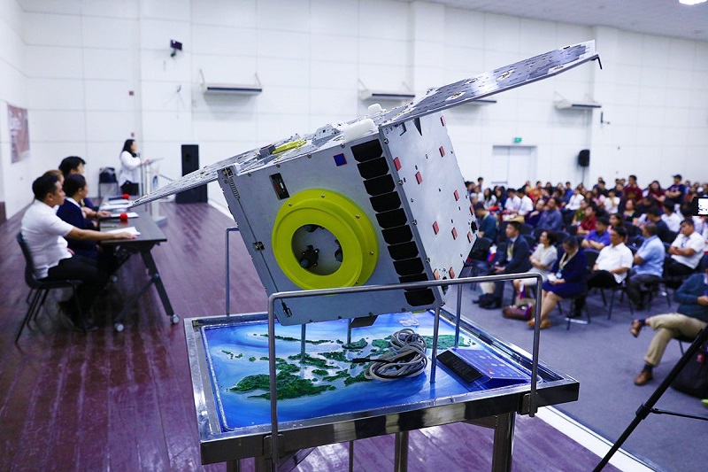
Diwata-2 is the second microsatellite built and designed by Filipinos, under the Development of Philippine Scientific Earth Observation Microsatellite (PHL-Microsat) Program.
It is funded by the DOST and monitored by the DOST-Philippine Council for Industry and Emerging Technology Research and Development (PCIEERD).
It was done through the collaboration among UP Diliman, the DOST-Advanced Science and Technology Institute (ASTI), Hokkaido University and Tohoku University.
A more technologically advanced sibling of the ground-breaking Diwata-1 microsatellite, Diwata-2 will orbit at a higher altitude of approximately 620km.
It features an increased lifespan and a sun-synchronous orbit that makes repeated environmental monitoring of specific places possible.
Like its predecessor, Diwata-2 carries a Wide Field Camera (WFC), Middle Field Camera (MFC), High Precision Telescope (HPT), and Spaceborne Multispectral Imager (SMI) with Liquid Crystal Tunable Filter (LCTF).
All these mission instruments have undergone rigorous ground calibration and testing to ensure that they will perform optimally at the new orbital conditions of Diwata-2.
But unlike Diwata-1, it features the deployable solar panels for increased power generation output and an enhanced resolution camera (ERC).
It also has two locally-made experimental modules: an Amateur Radio Unit for disaster and emergency communications and a Satellite Orientation Module for increased pointing accuracy.
Similar to Diwata-1, Diwata-2 was developed with the mentorship and support of Japan’s Hokkaido University and Tohoku University.
It has undergone major iterations since planning and design began in 2016, right after Diwata-1 was released from the International Space Station (ISS).
These include a simulation model, a mechanical test model, an engineering model, and finally, the flight model.
Diwata-2 has a plethora of sensors, called Sun Aspect Sensors (SAS), lining its body. These sensors serve two purposes.
One is to indicate location with respect to the sun. The sensor indicates which side faces the sun when struck directly by its light.
Second is the ability to calculate Diwata-2’s angle with respect to the sun, using light intensity. When it shines directly on the sensor, then that is typically when it is most intense.
Moreover, Diwata 2 also uses the stars. Since stars are fairly static landmarks, the microsatellite can utilise its Star Tracker Telescope (STT) to take a snapshot of a region of space.
It then compares this snapshot to the 360-degree star gallery included on board the satellite to estimate its current attitude and location.
Diwata-2 is a pivotal precursor to the next phase of Philippine space technology, called the Sustained Support for Local Space Technology and Applications Mastery, Innovation and Advancement (STAMINA4Space) Program.
The STAMINA4Space Program aims to build a local industrial base and enhance local space science and engineering expertise towards the establishment of the Philippine Space Agency.
Both Diwata-1 and Diwata-2 are Earth-observing microsatellites capable of capturing images of Earth for environmental assessment.
The satellite control, operation, and acquisition of experimental data will be done at the Philippine Earth Data Resource Observation Centre (PEDRO), which is housed by DOST-ASTI.


