


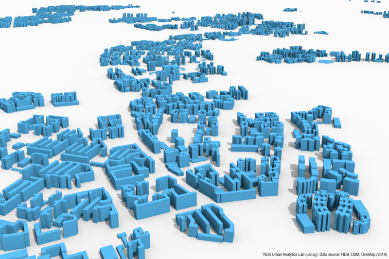
The Urban Analytics Lab at the National University of Singapore (NUS) has developed a 3D city model of all public housing (HDB) buildings in Singapore.
It generated the model by combining data from various open datasets. Since most of Singapore’s population reside in public housing, the datasets consist of information of the nation’s residential buildings.
The Urban Analytics Lab mentioned that it is a rising trend across the world for the release of 3D city models as open data. This is to allow researchers and practitioners of different disciplines to use 3D geoinformation to conduct various spatial analyses.
Hence, they too will be releasing this 3D city model of the HDB buildings as open data.
They will be offering the models in two formats: CityJSON and OBJ.
The CityJSON dataset contains information such as the address and number of units in each block. It even goes into detail of stating the number of rooms.
Both formats can be retrieved from their Github repository. Urban Analytics lab stated that while the dataset consists of significant data and covers almost all buildings, it is still under development.
Procedure
Urban Analytics Lab explained on how it achieved the formation of this model through the process of extrusion. They used information such as the height of each object, which is commonly attained using an airborne laser scanning method or lidar, and the geometry of the footprint. This process allows for the creation of LoD1 (block) models, which the developed 3D city model is currently presented as.
Challenges
The challenge associated with this process is the lack of open data on the heights of objects. In Singapore, there aren’t any publicly available lidar datasets.
Solution
Hence, Urban Analytics Lab used the number of storeys on each block as an estimate for the height of the blocks. Data on the number of storeys in each block has been made available as open data in Singapore. While they acknowledge that this method comes with its inaccuracies, it is largely used across the world and has aided various research work employing such data.
Urban Analytics Lab employed data from sources such as 2D building footprints from OpenStreetMap and HDB Property Information.
Both sources were linked using OneMap’s geocoder.
The dataset consists of information of all types of HDB buildings, which includes commercial building and carparks. Urban Analytics Lab added that there are about 12 thousand HDB buildings in Singapore.
There have been other initiatives which involved the need for use of 3D mapping technology for improving the analysis work of HDB buildings.
In an earlier OpenGov article, we reported on the Building and Construction Authority (BCA) and Housing & Development Board (HDB) having launched a Call for Proposal on using drones for Building Facade Inspection.
BCA and HDB feel that there is an urgent need of a new inspection model, using innovative solutions to improve the inspection efficiency, reduce safety risk to personnel, save time and at the same time being cost-effective.
The current inspecting building facades is a slow, resource and manpower intensive process.
The project is categorised into 2 main phases – Phase 1 comprising of Phase 1A & 1B, and Phase 2 comprising of Phase 2A & 2B.
Phase 1A focuses on the development of drone image mapping & processing software. To aid this process, the software should provide mapping and image indexing for traceability (position, geolocation, date, time of the survey, etc.).
Hence, technology solutions such as the visual 3D reconstruction of building for general building visualization and localisation of defects with the ability to pan, rotate and zoom should be enabled.
The 3D rendered model should be linked to an individual or group of high-resolution images to allow closer examination by inspectors and for allowing the overlay of defects or anomalies on its surfaces.


