


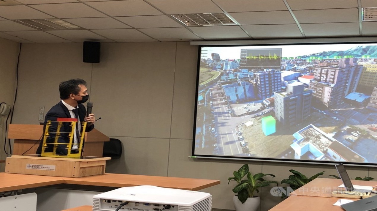
Developers from National Centre for Research on Earthquake Engineering (NCREE) exhibited a five-dimensional (5D) Smart City Seismic Simulation Platform. According to the Research Center of the National Institute of Applied Research, a 5D smart city platform named SmartES enables screening of buildings that need to be strengthened and simulates the impact of post-earthquake damage on buildings.
The geographic information system (GIS)-based platform integrates a structural monitoring system for buildings, the Taiwan Earthquake Loss Estimation System (TELES), satellite images, models created via modelling by Unmanned Aerial Vehicles (UAVs), and LiDAR point clouds. It could be used for pre-quake preparations to reduce earthquake damage and for post-earthquake emergency responses.
The platform was designed to show the extent of earthquake damage to the building using a five-colour system of red, orange, yellow, green and blue. On a five-colour scale, red indicates the most serious damage that can cause a building to collapse, and blue means minimal damage.
– NCREE researcher Wang Jinsa
Seismic simulation platforms could reveal seismic vulnerabilities in building and bridge structures that are vulnerable to seismic damage and need to be strengthened. The platform can also detect seismic events and provide real-time seismic notifications.
Once an earthquake occurs, data and information issued by the Central Weather Bureau, such as seismic waves, can be input into the platform to allow users to understand the possible loss caused by the earthquake and get information about the nearest fire departments and hospitals for post-disaster relief.
In addition, post-earthquake UAV patrols, immediate images of damaged buildings, information on rescue plans, and dangerous buildings that need immediate repair to prevent potential casualties in the event of an earthquake will also be notified via the platform. An evaluation report could be prepared 10 minutes after the earthquake.
SmartES has been linked to the government’s mapping database and databank of images collected by Formosat-5, and would likely be linked with the Ministry of the Interior’s collection of 3D maps in the next 1-2 years to make the platform more comprehensive.
The platform will combine Internet of Things (IoT) information, monitoring data, and surveillance images of various parts of every city and county in Taiwan to enable it to be applied to other natural disasters such as typhoons, flooding, and mudslides.
In recent years, the global trend of earthquake resistance and disaster reduction strategies for earthquake engineering has evolved from the most basic requirement to the requirement of maintenance of functionality after earthquakes. The strategies also focus on strengthening the country and resilience after the earthquake.
The National Earthquake Center intends to continue to improve the energy of core technologies and equipment, support and integrate the domestic industry, government and academia, focusing on the three major research and developments of seismic design, evaluation and reinforcement, situation simulation and risk assessment, and safety monitoring and early warning.
As reported by OpenGov Asia, the Taiwanese government has supported the development of smart services that are designed to address local issues, such as smart fire control/disaster reduction services in the field of governance. About 90% of fires in Taiwan occur in buildings. Firefighters have different psychological and training qualities such as stress resistance and mastery of equipment in the fire scene.
A Taiwanese company designed the “Smart 3D Realty Fire Control System” featuring 3D-BIM (Building Information Modeling), 3D map and panoramas shooting, and LiDAR. Based on the internal/external environments filmed and points of interest tagging, commanders can track the location and status of fire hoses and roads around the fire scene and dangerous objects inside the building; in addition, commanders can deploy in advance through the system on the way to the fire scene and fine-tune the deployment as needed after arriving at the scene.


