


Accurate maps of the Townsville flood frontier are being provided by researchers from the University of New South Wales (UNSW) Sydney within an hour using the latest satellite radar imaging technology.
Record-breaking floods threatening North Queensland are being mapped within an hour to provide snapshots of rising floodwaters, where previously such images were slow to produce and hampered by poor visibility.
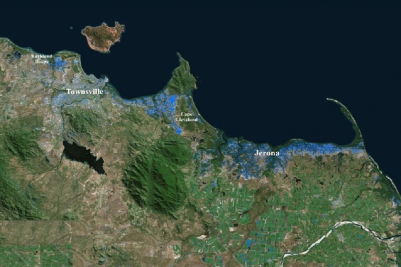
As reported, the flood map was put together with the use of European satellites that are fitted with radar imaging technology able to penetrate cloud cover.
This new type of flood intelligence could allow authorities to make decisions about critical infrastructure like switching off power stations before flood waters can reach them.
This is the first time that such advanced satellite technology has been used to map flooded areas from space according to Professor Linlin Ge of the University’s School of Civil and Environmental Engineering.
They would download very large volumes of satellite data from the European Space Agency.
One of the most advanced techniques available for flood mapping is being used by the team.
Synthetic aperture radar (SAR) is a radar imaging technology that can observe the earth day and night, through cloud cover or smoke.
Meanwhile, Interferometric SAR (InSAR) is a technique to combine a pair of SAR images in order to measure changes to terrain or ground displacement.
The result, InSAR coherence, is a by-product of InSAR processing and is a reliable and innovative measure showing feature similarity between the two images in the pair.
If an area is not flooded on the first image but inundated on the second image, this will lead to a significant reduction in InSAR coherence.
The coherence between the two SAR images can then be collected over the same area shortly before the flood as a baseline, which is called the pre-event pair.
The new technique of coherence change between the pre-event and co-event pairs can then serve as a reliable new tool to map flood extent and to identify flood fronts.
These data are then processed in order to generate comprehensive maps to show the extent of the floods.
The team made the data available to all through social media and can be viewed by following the Twitter hashtag #UNSW-GEOS.
Before using this latest technology, getting a composite, accurate and up-to-date image of floods has been difficult.
Heavy rains, strong winds, thick cloud and lightning can make it impossible or dangerous to fly an aircraft to monitor floods, like the one in North Queensland, which stretches 700 km from Cairns to Mackay.
Although elements may be favourable, it could take days to piece together a ‘big-picture’ view of flood movement, by which time the floods could have already moved on to a new front.
Even views from space via optical satellites can be made redundant if large parts of a flood-ravaged region are obscured by clouds.
The team is expected to provide round-the-clock monitoring of the data to continue for the next few days.
Townsville is at the epicentre of an unprecedented monsoonal downpour with more than a year’s worth of rain dumped in just a few days, and three to four more days of torrential rain expected.


