


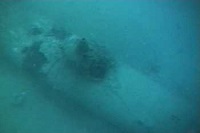
Lying 55 metres underwater off Sydney’s northern beaches is the wreck of a Japanese submarine called M24.
According to a recent press release, the M24 can now be explored online in 3D. The site is not a public diving site as it is still the grave of the two Japanese submariners who died on their mission.
M24 was one of three Japanese midget submarines to enter Sydney Harbour in 1942 and is the only submarine remaining where it sank more than 75 years ago.
It was not until November 2006, that a group of weekend divers located the still intact Japanese midget submarine off Bungan Head, Newport in Sydney, Australia.
The submarine was entangled in nets below on the seabed.
Following the discovery of the midget submarine, the NSW and Australian governments jointly protected the site under the NSW Heritage Act 1977 and the Commonwealth Historic Shipwrecks Act 1976.
The NSW Government continues to work collaboratively with the Commonwealth and Japanese governments to protect this highly significant site.
Like all shipwrecks, the submarine has a fascinating story to tell. It held the events in Sydney Harbour on the night of 31 May and the early morning of 1 June 1942.
Moreover, it embodied the role of the Japanese midget submarines as well as the Japanese submarine campaign along Australia’s eastern seaboard during World War II.
A high-resolution digital 3D model has been created of the submarine. The model provides accurate detail of the site and shows what the submarine looks like below sea level.
The midget submarine is internationally significant, and its management by the NSW Government is recognised by UNESCO as world’s best practice.
Environment Minister Gabrielle Upton said there are many challenges in the ongoing protection of the site.
Early last year the first public divers were allowed to respectfully explore the site, but not everyone has the specialist diver training to do this.
The Heritage Division, Office of Environment and Heritage (OEH) continues to actively manage the site and undertakes an ongoing program of archaeological surveys.
The model will provide a baseline recording that will allow OEH to monitor changes to the wreck over time and also allow the public to visit the site without having to get wet.
The 3D recording project was initiated by OEH with assistance from the Australian and New Zealand Chapter of an organisation focused on exploring.
The project was led by maritime archaeologist Matt Carter who was granted a special access permit to undertake the diving survey.


