We all know that human activities are Location and Time dependent. I would wake up in the morning, being aware of where I am and what I need to do that ‘very’ morning, which includes where I needed to go and be. These are key for digital transformation and smart initiatives. Unless we tie in our initiatives to ease and simplify human activities, we may find the challenge of gaining traction on these efforts. Imagine Uber’s car sharing and booking application running without the awareness of location. Imagine AirBnB’s platform working without time and location. I would theorise almost all of human activities are bounded by location and time parameters.
Now, with the pervasive use of technology at our fingertips, we gain even more information from the cellular data streams of our smartphones, the Twitter feeds, Google and Apple locations services and Facebook check-ins, etc. Mining these data gives us visibility of human activities never before available.

Understanding these datasets would allow cities and organization to better serve and maximise their target audiences’ experience.
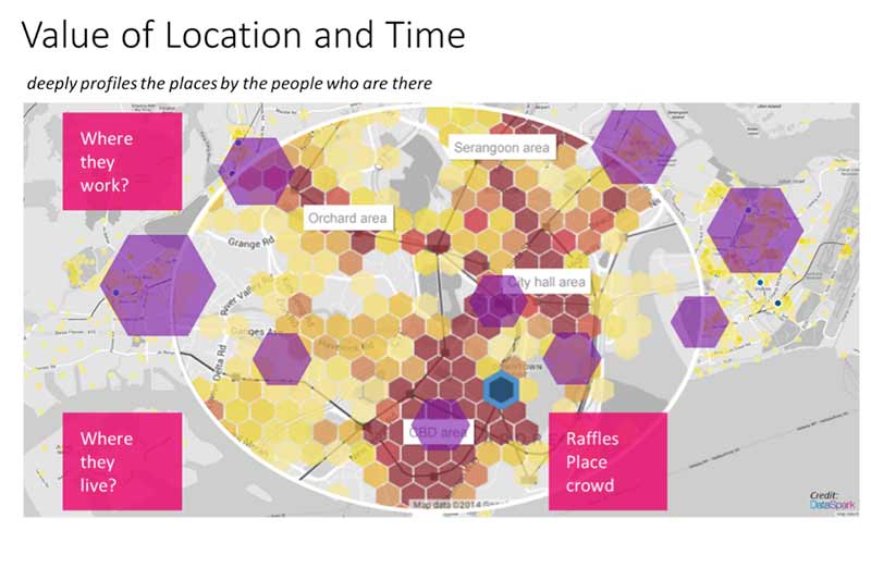
As an example, take the simple planning of transportation services for the commuters across a sub-section of Singapore’s MRT network.

In a simple test (shown) above, we would assume that almost everyone would have chosen the shortest route – i.e. the via Dhoby Ghout and City Hall. This is also where the two most popular location to break a journey can take place. Using cellular data sets, the results were quite the opposite, most people used one of the longest routes.

Please note that this scenario is now obsolete as there was a shorter route available since this analysis, there’s now an MRT line that connects Little India to Bugis and provides a 15 minute journey. It would be good to see if the investment by the government and Land Transport Authority was worth it.
While the above uses cellular data, we can also use data from smart cards that was used by the commuters to pay for the rides.
Apart from transport planning, think of the value of these data sets to the retailers, bus operators, banks, etc.
In Seoul, the City worked with cellular operators to gain insights into the midnight travelling patterns of revellers to craft a dynamic service route that not only ensures availability of transportation services, but the profitability of the service providers to ensure sustainable operations.

The speed of urbanization in most of Asian countries are creating multiple issues, from movement of people, goods and services, road congestions and liveability. Some of the efforts by cities like Singapore and Makati City should be emulated.

Here is where I see an amazing use of data from Internet of Things devices to understand and help cities manage the sustainability of the cities, by helping the cities modify, adapt and improve their policies for redevelopment to cater for the changes urbanization brings.

As many countries and cities now embark on infrastructure projects and embedding IoT devices to monitor and analyse human activities, we will be given the opportunity to be able to access the tremendous amounts of data. Corporations and businesses can also access these data (when made public and anonymized) to gain better insights and allow them to design and deliver profitable and sustainable services.
As an example, Singapore with its Smart Nation Intiatives, together with the Land Transport Authorities’ ERPII mega project and SLA and URA’s development of 3D datasets of built areas, will provide unprecedented amount of data. Are organizations ready to take advantage of these data?