


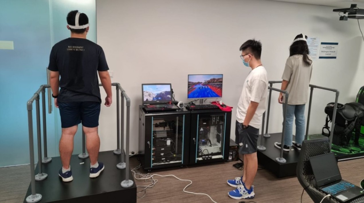
Through the use of Virtual Reality (VR) technology and a vibrating platform, also known as a shake board, students will soon not only learn about earthquakes through slideshows but get to experience them too. This is particularly eye-opening for students in Singapore where earthquakes are non-existent.
While the city-state sits outside of the Pacific Rim of Fire and is hence spared natural hazards like earthquakes and volcanic eruptions, National University of Singapore (NUS) undergraduates can now experience the tremors first-hand through the project supported by the Learning Innovation Fund – Technology (LIF-T).
The VR-based learning environment not only plugs a gap in earthquake education, where fieldwork is limited but also simulates the earth processes that lead to earthquakes, such as plate tectonic movements. Fieldwork involves visiting specific sites, but the best thing you could see is a crack in the land surface, a fault line, or a volcano. So, there is some indication of an earthquake, but it is static because, of course, you don’t want to be there when the ground is shaking.
Getting to this point has not been easy, he shared, with COVID-19 delaying the project by close to a year due to supply chain disruptions. The team also had to surmount another obstacle – creating virtual scenarios that they, and in some cases, all humanity, have not witnessed personally.
Associate Professor Feng Chen-Chieh from the Department of Geography has encountered several earthquakes, the most recent being just last December when he was on vacation back home, which had him grabbing onto the desk for 10 seconds during a meeting with colleagues. While he knows how earthquakes occur, he has not seen the many earth processes that either happened millions of years ago or take place in areas inaccessible to humans.
Take the formation of mid-ocean ridges as an example. They occur along divergent plate boundaries deep underwater, where tectonic plates spread apart, creating a new ocean floor. As the plates separate, molten rock from within the earth rises to the seafloor, producing volcanic eruptions and in turn, earthquakes.
Representing a divergent plate boundary in deep water in VR is challenging, as no one has actually seen this in reality, so they had to imagine how they look based on published materials. The team had many discussions on how the phenomenon could be portrayed to facilitate learning earthquake concepts. Eventually, they settled on mimicking the experience of diving to the ocean floor.
There was also the issue of ensuring the domain knowledge experts – the NUS team – and the graphic designers understood each other. This required various refinements along the way to make sure that the depictions were accurate yet engaging.
The ultimate goal is to enhance students’ experiences in the classroom, adding a touch of realism to earth science concepts that can sometimes be hard to visualise especially when they happen over millions of years. We compress that into a matter of seconds.
As reported by OpenGov Asia, medical first responders must promptly classify victims according to the severity of their injuries in a mass casualty incident. Creating realistic scenarios to train these responders can help better prepare them for such crises. However, real-life mass casualty simulation drills require an immense amount of planning, manpower, time, and space.
Virtual reality (VR) simulation drills can help ease the number of resources needed compared to physical drills, but most VR simulations involve point-and-click actions using gaming controllers, or they simply offer users a visual simulation of an incident with no interactivity. These virtual simulations lack the direct and natural tactile interaction that stimulates cognitive and muscle memory.


