


In a world-first, a satellite-based global coral reef bleaching monitoring system will scan the Earth’s oceans for coral-killing bleaching events in real-time. The Allen Coral Atlas project, an international research collaboration featuring University of Queensland scientists, are using unprecedented detailed habitat maps of all global coral reefs – over 230,000 of them – to detect reef bleaching anywhere in the world.
Dr Chris Roelfsema, from UQ’s Remote Sensing Research Centre, said the digital atlas tool was desperately needed, given the state of the world’s coral reefs. “The current prognosis for the world’s coral reefs is bleak,” Dr Roelfsema said.
He noted that with ever-warming, more polluted and acidic oceans, models predict that 70 per cent to 90 per cent of coral reefs will be lost by 2050. Until now, there hasn’t been a global system in place to monitor coral reefs under the stresses that may lead to their deaths.
The Atlas team have now created this incredible tool, which monitors the global health of coral reefs and bringing new hope to support conservation efforts. The Allen Coral Atlas will allow the scientists to offer critically important information to scientists, decision and policymakers, something that’s urgently needed for rapid response and conservation.
Previously, only disparate data sets and maps were available to scientists and policymakers. The Allen Coral Atlas allows anyone with internet access to monitor and download data on every major reef globally at never-before-seen detail, across time.
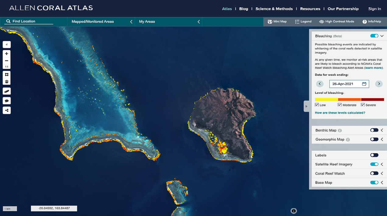
Satellites detect variations in reef brightness by using high-resolution satellite imagery powered by an advanced algorithm indicating whether reefs are under stress or resilient to marine heatwaves. The monitoring capability will help the team to see, where and to what extent coral bleaching is likely to be occurring as well as where it isn’t bleaching so the scientists can identify resilient reefs.
The platform can observe where corals are bleaching throughout the world, ranging from no bleaching to severe. Once the team knows where this is happening, governments and NGOs on the ground can swoop in to take action sooner, rather than later, Dr Roelfsema stated.
The project began in 2018, when a new generation of cube satellites operated by Planet, allowed for a four-metre-per-pixel mosaic image of the world’s coral reefs to be assembled. Satellite data was then cleaned up via the Carnegie Institution – Asner Lab, before UQ scientists used the data to create the first global map that represents coral and algae, seagrass, sand, rubble and rock.
“This is just the first global version of our monitoring system, with the partnership intending to improve and expand it to include a broader range of impacts on reefs such as land-sea pollutants and sediments,” Dr Roelfsema said. “This first, truly global reef monitoring system is simply a drop in the bucket for what is to come.”
More on the Atlas Monitoring System
The Atlas monitoring system detects variations in reef brightness using high-resolution satellite imagery powered by an advanced algorithm indicating whether reefs are under stress caused by marine heatwaves. With this tool, users can see where corals are bleaching at a global scale and in bi-weekly increments from January 2021 onward.
“Our ability to monitor changes in coral reef condition has always been a clear but challenging requirement to drive decisions on where to apply our best restorative and protective strategies,” said Dr Greg Asner, Managing Director of the Allen Coral Atlas, and Director of the Arizona State University Center for Global Discovery and Conservation Science. “The new Atlas Monitoring System is a major step in our effort to bring eyes to the reef at a global scale and yet with extraordinary detail needed for progressive reef interventions.”


