


Cities nowadays are growing increasingly complex and dynamic, this means that scientists must find creative ways to study the geological, ecological and environmental aspects of urban environments.
An important modern technique for environmental science is Remote Sensing – studying the surface of the Earth using data and images collected by airborne platforms (plane, helicopter or drone) or spaceborne platforms (satellites).
While the data provides critical information to scientists, planners and policymakers, remote sensing data is expensive to acquire and process, and therefore, cutting edge research in Hong Kong is limited in part by available data.
However, the Faculty of Science at the University of Hong Kong recently announced that it has received a large donation of remote sensing data for Hong Kong and other locations from a local industry partner with an estimated value of at least HK$9.3 million.
The data includes LIDAR (laser ranging) topographic data and very high-resolution aerial photography of much of the SAR, with extremely high spatial resolution, in addition to similar data other parts of the world allowing HKU scientists to explore for resources and carry out environmental assessments in various settings from Australia to South America.
The valuable and unique data will be used extensively in both research and teaching, the Dean of Science and ecologist in the School of Biological Sciences noted.
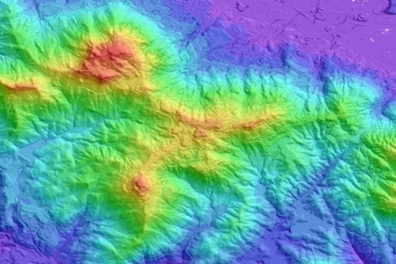
LIDAR is an exceptional technology and allows for details to be captured of vegetation as well as the ground on which it sits. The resolution of the data allows the recreation of tree cover, tree height and the size of tree trunks which allow detail vegetation maps in addition to those of the surface.
LIDAR data for Hong Kong are an extremely important dataset. The data were acquired by DiMap using a fixed-wing aircraft flying at low airspeed, allowing them to collect a very high density of laser ranging points. The result is the highest resolution topographic information that is available for such a large fraction of Hong Kong.
The donated LIDAR data will allow HKU geologists to identify hotspots for further study, map out geological structures and geomorphology of the region, and carry out new studies of bedrock structure and slope stability, as well as environmental studies.
Together with studies of minerals at a microscopic level, the datasets add additional dimensions to the analysis of our researchers. Such data are invaluable for coastline studies in studying coastal ecology, flood hazards and other topics.
A professor from the Department of Earth Sciences noted that because the LIDAR data can provide accurate, high-resolution elevations of low-lying areas, it is a highly valuable data set for flood risk analysis, relevant to urban planning, coastal engineering works and natural hazard insurance industry. It is, therefore, highly beneficial to Hong Kong as the region is heavily reliant on the land resources of low-lying coastlines.
One of the ways the Faculty of Science engages in Knowledge Exchange is through collaboration with local industry partners.
An Associate Professor in the Department of Earth Sciences works closely with the Director of Dimap. He noted that Dimap’s interest is to be involved in the local geospatial science community to work together on HK problems but also to develop competency and cutting-edge solutions in the HK office to apply them in the worldwide projects. Such relationships help translate fundamental research from the laboratory to applied, real-world solutions.
One of the main goals in the Department of Earth Sciences, and Faculty of Science, in general, is to carry out high impact, fundamental research that both unveil mysteries of nature and at the same time improves society.


