


Australia’s Monash University had produced a high resolution vegetation map of Victoria on the back of one of the most devastating bushfire periods in history.
According to a recent press release, the vegetation map could help authorities manage future outbreaks and improve agricultural planning.
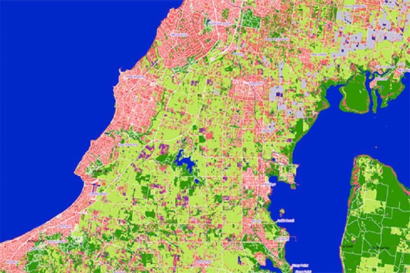
First land-cover map of Victoria
Researchers at the University’s Faculty of Information Technology have used the most established data from the European Space Agency’s Sentinel-2 satellite to develop the first land-cover map of Victoria at 10m spatial resolution.
The map is claimed to be the most detailed map of its kind produced in the country and is the result of the analysis of more than 4300 satellite images.
Victoria is the first state or territory in Australia to have access to this revolutionary image map, which is 25 times finer and more detailed than those currently produced by the Australian government.
According to a Senior Research Fellow from the University’s Faculty of Information Technology, who is also the Project Lead, Earth observation satellites have provided information about the status of large-scale agricultural, environmental and climate problems for years.
The pictures have aided in informed decisions. However, these pictures were largely static and unreliable.
There is a new era in Earth observation. The latest-generation satellites have started to produce images of Earth frequently, in high resolution and at no charge to end users.
There is an unprecedented opportunity to monitor the dynamics in the region, and the country over time, and establish a course of action that reflects the changing nature of the environment.
Other applications
Additionally, there are several potential scenarios or high-value applications to which this vegetation map of Victoria can be applied to. These are:
- Fire Management
It is critical to know the condition of trees and grasslands, particularly their vegetation water content and biomass.
Knowing this will derive high-quality fuel-load maps that can be used to model how bushfires spread and how prescribed burns can be conducted.
- Agricultural Planning
Having knowledge of the type of crops and stress over the territory is critical to optimise irrigation and use of pesticides/herbicides, or to forecast potential exports through yield estimates.
- Flood Management
Predicting the water levels after a rain event requires to precisely know how much of the rain is absorbed by the soil, which is essentially dictated by the type of vegetation.
- Pollution Management
Mapping the type of privately and publically owned vegetation is essential for monitoring the different types of pollutions that a city can safely absorb.
- Mining site Monitoring and Rehabilitation
Satellite images can help monitor abnormal vegetation growth.
Plans
Great potential is shown by this very colourful map in refined modelling of the state’s vegetation, which highlights the possible improvements that may be required.
Current plans include looking into how this can be replicated in the other states and territories in Australia.
The Victorian vegetation map is now available online here.


